2) How do climate and environmental change impact terrestrial ecosystems, particularly agroecosystem production and resulting food security, particularly in monsoonal climates, drylands, and the most vulnerable regions?
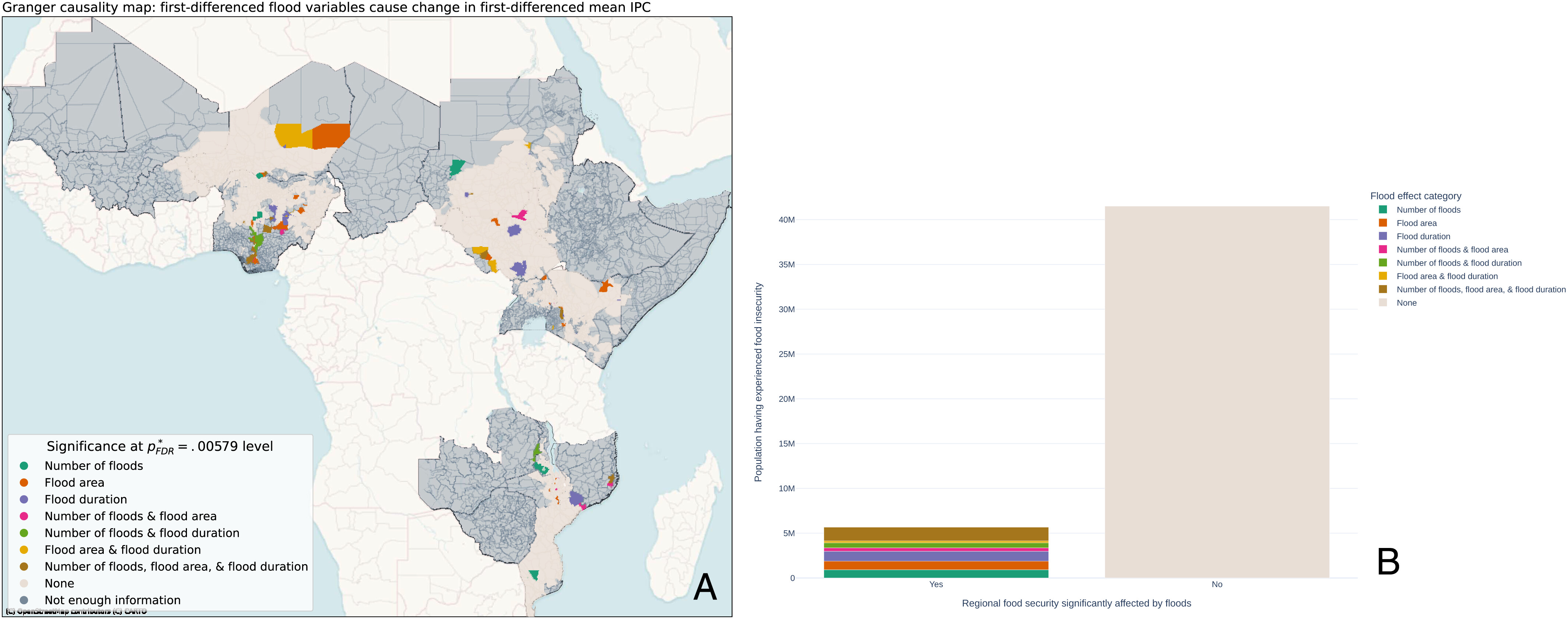
The impact of flooding on food security across Africa

Recent record rainfall and flood events have prompted increased attention to flood impacts on human systems. Information regarding flood effects on food security is of particular importance for humanitarian organizations and is especially valuable across Africa’s rural areas that contribute to regional food supplies. We quantitatively evaluate where and to what extent flooding impacts food security across Africa, using a Granger causality analysis and panel modeling approaches. Within our modeled areas, we find that ∼12% of the people that experienced food insecurity from 2009 to 2020 had their food security status affected by flooding. Furthermore, flooding and its associated meteorological conditions can simultaneously degrade food security locally while enhancing it at regional spatial scales, leading to large variations in overall food security outcomes. Dedicated data collection at the intersection of flood events and associated food security measures across different spatial and temporal scales are required to better characterize the extent of flood impact and inform preparedness, response, and recovery needs
Learn more here: Reed et al 2022
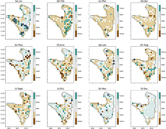
Moisture and temperature influences on nonlinear vegetation trends in Serengeti National Park

Monthly plots of LAI3g Trend categorization: Brown = monotonic browning; GtoB = reversal from greening to browning; BtoG = reversal from browning to greening; Green = monotonic greening; NaN denotes the remaining Trend has more than one extrema and cannot be classified in any of these categories; overplotted on some grid cells is black hatch lines, denoting that our surrogate test indicates the monotonic greening or browning Trend is significant at 0.05 level.
While long-term vegetation greening trends have appeared across large land areas over the late 20th century, uncertainty remains in identifying and attributing finer-scale vegetation changes and trends, particularly across protected areas. Serengeti National Park (SNP) is a critical East African protected area, where seasonal vegetation cycles support vast populations of grazing herbivores and a host of ecosystem dynamics. Previous work has shown how non-climate drivers (e.g. land use) shape the SNP ecosystem, but it is still unclear to what extent changing climate conditions influence SNP vegetation, particularly at finer spatial and temporal scales. We fill this research gap by evaluating long-term (1982–2016) changes in SNP leaf area index (LAI) in relation to both temperature and moisture availability using Ensemble Empirical Mode Decomposition and Principal Component Analysis with regression techniques. We find that SNP LAI trends are nonlinear, display high sub-seasonal variation, and are influenced by lagged changes in both moisture and temperature variables and their interactions. LAI during the long rains (e.g. March) exhibits a greening-to-browning trend reversal starting in the early 2000s, partly due to antecedent precipitation declines. In contrast, LAI during the short rains (e.g. November, December) displays browning-to-greening alongside increasing moisture availability. Rising temperature trends also have important, secondary interactions with moisture variables to shape these SNP vegetation trends. Our findings show complex vegetation-climate interactions occurring at important temporal and spatial scales of the SNP, and our rigorous statistical approaches detect these complex climate-vegetation trends and interactions, while guarding against spurious vegetation signals.
Learn more here: Huang, McDermid et al 2021
